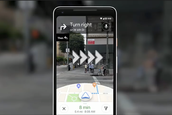
Google Maps is an indispensable application. And thankfully for those of us that rely on it, over the past years, Google has mapped more than 21 million miles in 220 countries and plotted hundreds of millions of businesses across the globe. At its recent I/O 2018 event in May, Google demonstrated some exciting new functionality that its team had been looking at for Google Maps.
Google claims walking navigation could be revolutionised by how it has used augmented reality to combine the power of a user’s camera phone with Street View and Google Maps data.
Using the camera’s functionality you scan the street in front of you. This connects in with Google Maps to instantly show you which way to go. Using augmented reality, the view brings up virtual signposts displaying the locations around you – landmarks such as restaurants, cafés, theatres and so on.
Google has also been developing an augmented reality animated guide – and in this case, it was a fox – which can show you the way to go.
Dubbed VPS – for visual positioning system – the augmented reality will be fantastic for real-time walking directions for both delivery companies and distributors running their own fleets. In city centres, where delivery drivers might need to park some way from their pickup or delivery, VPS technology could offer real improvements in delivery times. It’s often not immediately obvious which way to go from Google Maps when you’re walking, and you end up turning around in circles trying to see if the GPS is picking up which direction you are facing. And if not, you end up walking some way down the road, waiting for the blue dot on your map to catch up with you to confirm if you’ve gone the right way or not. A short video of “how it could look” shows what the Google team has been working on and how much easier the VPS will make walking navigation.
While no official launch date for VPS has been given – and the discussion was more of a teaser than an official product release – we’re hopeful that the positive reaction to the idea of the technology will spur Google into developing and releasing this soon. Millions of companies worldwide use the Google Maps API within their websites and apps – and our own Springboard Delivery app uses it too. So the new functionality would assist our customers’ drivers when making walking deliveries.
